01/07: Here a Bird, There a Bird, Everywhere a Bird
Category: General
Posted by: The Agnew Family
Today we celebrate Canada Day. We learned that today is also Memorial Day for Newfoundland. On July 1, 1916 the Dominion of Newfoundland troops suffered huge losses at The Battle of Somme during the First World War. While Ed and I were at Cape Mary's Ecological Reserve we saw part of a Memorial Day service.
I learned a second thing today --- how to embed a google map into my blog. Using your mouse you can move the map around and zoom in and out. If you click on the map, google maps will load in a new window.
We traveled clockwise around the route. The first stretch south was highway 90. The Newfoundland "paper" map, shows one town and that is where highway 90 intersections highway 91 so we were surprised to see a lot of homes in the first part of our drive. All the homes were on or near ponds so we're wondering if this is "cottage country". Continuing south on highway 92 we just see trees, lots of trees, some rocks and water and just the odd house here and there. The first town is Branch where highway 92 and highway 100 intersect. There are a number of homes here and a small harbour. The landscape changes as we travel west, we see fewer trees and more bogs, included a Cranberry bog (there was a sign) and a few fields. At least what looked like fields with fenced loading areas for livestock. Turning south towards the reserve, we see more fields and livestock loading areas. When we reached the reserve we saw sheep grazing.

When we walked toward the birding area we had to watch where we stepped as the sheep had free rein.
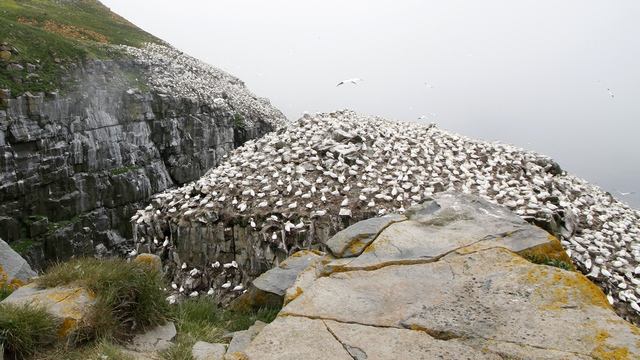
Over 32,000 nesting pairs can be found in this area. 11,000+ Northern Gannets, 10,000+ Common Mures, 10,000+ Black-Legged Kittiwakes, 150+ Razorbills, 60+ Black Guillemot, 1,000+ Thick-billed Mure. The birds nest in layers --- the Northern Gannet are found on top of the rocks, the Kittiwakes and ledges below the Gannets, the Razorbills below the Kittiwakes and the Murres below the Razorbills. The photo shows only a small portion of the nesting area.
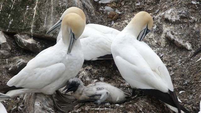
The Northern Gannet chicks have hatched. Most of the chicks are being sat on but this one seemed to be getting some air.
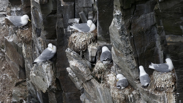
Black-legged Kittiwakes build their nests on small ledges to try and prevent the bigger birds (predators) from landing.
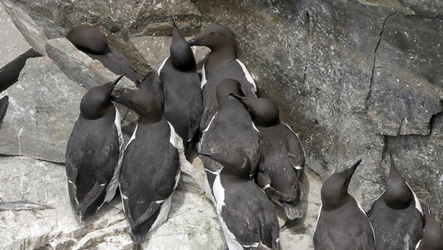
Common Mures.

Ed took a lot of amazing shots. It was hard choosing the shots to show.
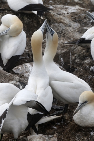
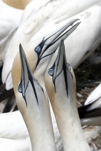
Gannet pairs are monogamous and may remain together over several seasons, if not for all their lives. The pairs separate when their chicks leave the nest but they pair up again the following year. The knocking of beaks is part of the pairs ritual behaviour.
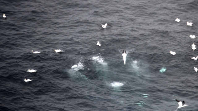
This isn't a very good photo but it's the best I have (for some reason Ed didn't take photos of the birds diving). The splashes are where Gannets dove into the water. The birds would be flying normally then suddenly aim straight down and dive into the water. A minute or so later the bird would surface. The "blobs" under the water are the birds swimming.
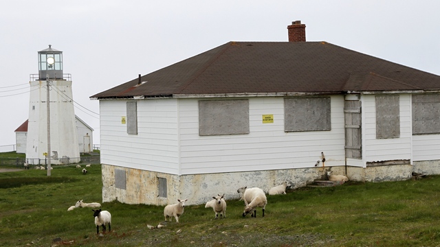
Cape St. Mary lighthouse and more sheep.
Leaving the reserve, we drove north on highway 100. Each cove we passed was a village but no docks or boats, fishing or otherwise to be seen. We did see a field with 14 cows and few gardens. Placentia is a small city. Here there was a harbour and some industry.
Ed decided to do some geocaching. One of the geocaches was at Fort Royal National Historic Sites. Happy Canada Day --- there was no charge today.
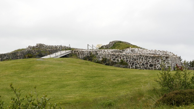
Fort Royal is a French fort built in 1687 on top of a hill to protect the harbour.
Another geocache took us to a blocked off driveway at the edge of a field. This is what we found:
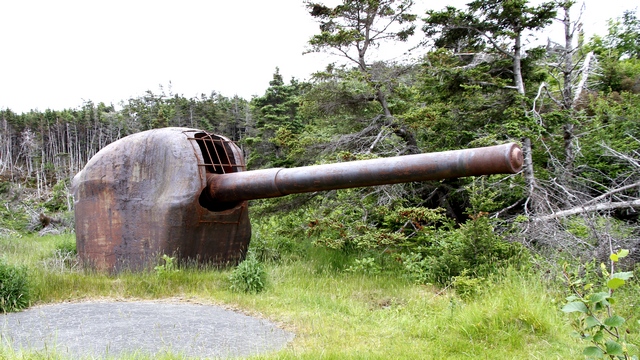
From the cache information and other websites, Ed was able to learn it is very rare, only a half dozen exit, it fired a 105 lb. 6" armour piercing shell at least 25KM (15 miles) at 5 per minute and electrically operated. Installed by the US Navy to protect US/Canadian/British ships operating in the nearby harbour." Another web site states: "Argentia 282 Coastal Defense Battery has aesthetic value as its design and construction technique are rare in the province. Known as the “200 Series” bunker, this underground fortification is likely the only one of its kind remaining with its original artillery guns in place. Built of concrete, the bunker is covered with soil and vegetation, blending into the landscape as its original design intended. The rare 6-inch Seacoast Guns M1903A2 remain in situ, complete with shields." We're surprised that it's laying basically abandoned in a field.
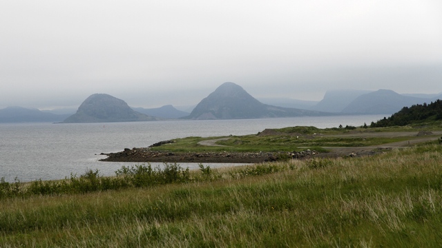
A third geocache took us near the Argentia ferry dock. Just loved the hills in the background.
The final leg of the drive was similar to what we have seen elsewhere in the Avalon Peninsula --- trees, rocks and water.
I learned a second thing today --- how to embed a google map into my blog. Using your mouse you can move the map around and zoom in and out. If you click on the map, google maps will load in a new window.
We traveled clockwise around the route. The first stretch south was highway 90. The Newfoundland "paper" map, shows one town and that is where highway 90 intersections highway 91 so we were surprised to see a lot of homes in the first part of our drive. All the homes were on or near ponds so we're wondering if this is "cottage country". Continuing south on highway 92 we just see trees, lots of trees, some rocks and water and just the odd house here and there. The first town is Branch where highway 92 and highway 100 intersect. There are a number of homes here and a small harbour. The landscape changes as we travel west, we see fewer trees and more bogs, included a Cranberry bog (there was a sign) and a few fields. At least what looked like fields with fenced loading areas for livestock. Turning south towards the reserve, we see more fields and livestock loading areas. When we reached the reserve we saw sheep grazing.

When we walked toward the birding area we had to watch where we stepped as the sheep had free rein.

Over 32,000 nesting pairs can be found in this area. 11,000+ Northern Gannets, 10,000+ Common Mures, 10,000+ Black-Legged Kittiwakes, 150+ Razorbills, 60+ Black Guillemot, 1,000+ Thick-billed Mure. The birds nest in layers --- the Northern Gannet are found on top of the rocks, the Kittiwakes and ledges below the Gannets, the Razorbills below the Kittiwakes and the Murres below the Razorbills. The photo shows only a small portion of the nesting area.

The Northern Gannet chicks have hatched. Most of the chicks are being sat on but this one seemed to be getting some air.

Black-legged Kittiwakes build their nests on small ledges to try and prevent the bigger birds (predators) from landing.

Common Mures.

Ed took a lot of amazing shots. It was hard choosing the shots to show.


Gannet pairs are monogamous and may remain together over several seasons, if not for all their lives. The pairs separate when their chicks leave the nest but they pair up again the following year. The knocking of beaks is part of the pairs ritual behaviour.

This isn't a very good photo but it's the best I have (for some reason Ed didn't take photos of the birds diving). The splashes are where Gannets dove into the water. The birds would be flying normally then suddenly aim straight down and dive into the water. A minute or so later the bird would surface. The "blobs" under the water are the birds swimming.

Cape St. Mary lighthouse and more sheep.
Leaving the reserve, we drove north on highway 100. Each cove we passed was a village but no docks or boats, fishing or otherwise to be seen. We did see a field with 14 cows and few gardens. Placentia is a small city. Here there was a harbour and some industry.
Ed decided to do some geocaching. One of the geocaches was at Fort Royal National Historic Sites. Happy Canada Day --- there was no charge today.

Fort Royal is a French fort built in 1687 on top of a hill to protect the harbour.
Another geocache took us to a blocked off driveway at the edge of a field. This is what we found:

From the cache information and other websites, Ed was able to learn it is very rare, only a half dozen exit, it fired a 105 lb. 6" armour piercing shell at least 25KM (15 miles) at 5 per minute and electrically operated. Installed by the US Navy to protect US/Canadian/British ships operating in the nearby harbour." Another web site states: "Argentia 282 Coastal Defense Battery has aesthetic value as its design and construction technique are rare in the province. Known as the “200 Series” bunker, this underground fortification is likely the only one of its kind remaining with its original artillery guns in place. Built of concrete, the bunker is covered with soil and vegetation, blending into the landscape as its original design intended. The rare 6-inch Seacoast Guns M1903A2 remain in situ, complete with shields." We're surprised that it's laying basically abandoned in a field.

A third geocache took us near the Argentia ferry dock. Just loved the hills in the background.
The final leg of the drive was similar to what we have seen elsewhere in the Avalon Peninsula --- trees, rocks and water.