Wednesday, January 25, 2006
Green Grass
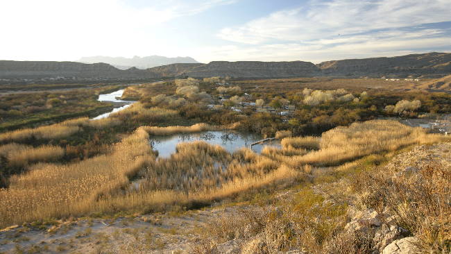
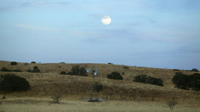
Llano Grande Lake Park in Mercedes, Texas is our destination for today. As it is only 3 1/2 hours from Laredo, Ed spent some time wandering around the lake looking for birds.
The park is very impressive --- huge concrete pads to park on and a green grass lawn (yes they water regularly). Zaph thought that grass was great, he spent a lot of time rolling around on the lawn with his toys. We are booked into this park for 5 weeks so Ed will have time to work on slide shows, wash the trailer, fix a few things and Zaph I will enjoy the grass, walk around the pond and walk down the levee.
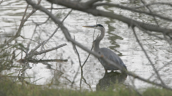
A great blue heron hanging out in the lake.
The park is very impressive --- huge concrete pads to park on and a green grass lawn (yes they water regularly). Zaph thought that grass was great, he spent a lot of time rolling around on the lawn with his toys. We are booked into this park for 5 weeks so Ed will have time to work on slide shows, wash the trailer, fix a few things and Zaph I will enjoy the grass, walk around the pond and walk down the levee.
A great blue heron hanging out in the lake.
Tuesday, January 24, 2006
Laredo
Laredo, another one of the towns from the old westerns on tv --- I think I might have watch too much television as a kid. We decided to stop here as the Laredo website made the Mexican town of Nuevo Laredo sound interesting. Nuevo Laredo was a cross between the two other Mexican towns we had seen so far --- lots of pharmacies, dentists and doctors who were willing to help you but not entirely touristy. It was a little unnerving to see police pickup trucks driving up the main street with 2 or 3 policeman in the box of the truck with machine guns. Apparently, there are gang wars going on and there had been a shooting the day before. We wandered around for a couple of hours and headed back to the state park. We were very happy to find The park was an unexpected gem in Laredo.
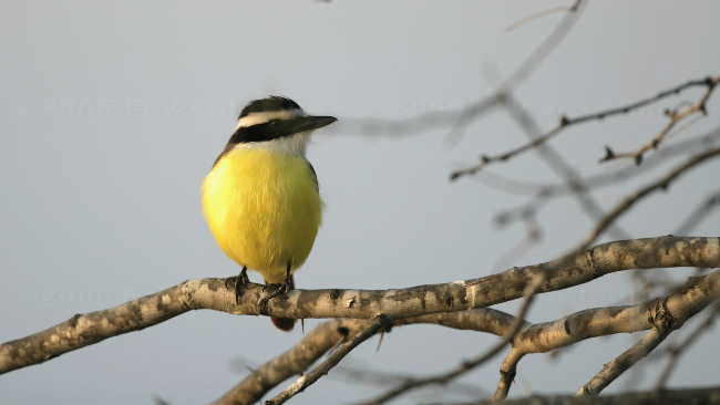
Great Kiskadee
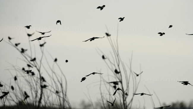
One of the many flocks of birds
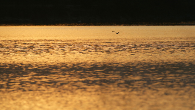
A solitary bird flying over the lake as the sun begins to set
Great Kiskadee
One of the many flocks of birds
A solitary bird flying over the lake as the sun begins to set
Monday, January 23, 2006
More Driving
We said our farewells to Big Bend National Park and headed east to Laredo, Texas. Happily the drive was only 9 hours. The scenery changed from desert to grassland — they must get more rain here (but maybe not this year). Our home for the next two days is the Casa Blanca Lake International State Park. This beautiful spot is a stopping off place for a lot of migratory birds.
Sunday, January 22, 2006
Take a Hike!
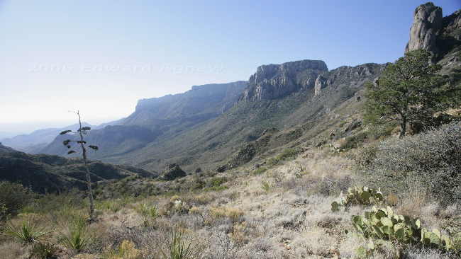
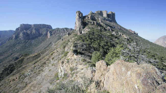
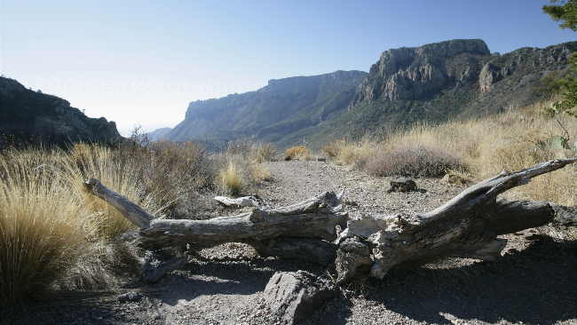
We decided that we had seen a lot of the park and it was time to hike one of the slightly longer trails — I wasn’t up to a 14 mile trail so we opted for a 4.8 mile trail called the Lost Mine Trail. The first 2.4 miles of the trail was uphill — as you returned on the same path it was down hill for the last 2.4 miles. The trail followed the side of a mountain giving us some great views of the area. The 2.4 miles up ended on a ridge that looked down into a pine valley on one side and out across to Toll Mountain and Casa Grande on the other side.
A view from the trail.
Casa Grande from a lava dike
Another view.
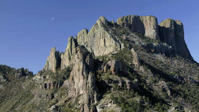
Casa Grande
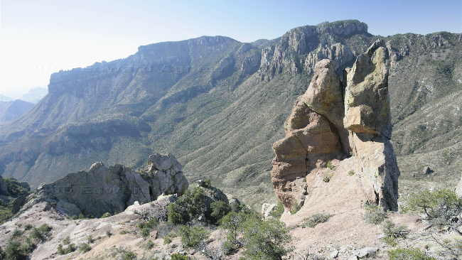
A view from the top of the ridge
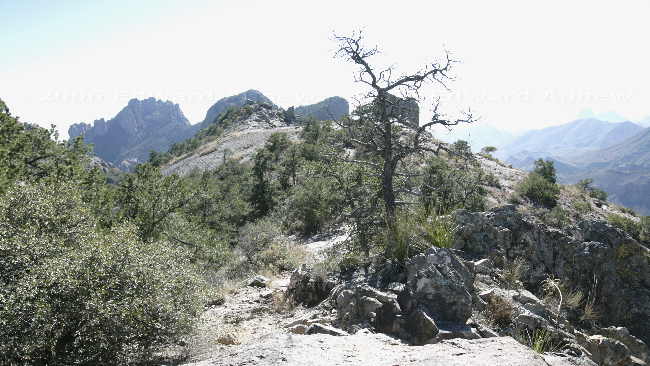
The ridge at the end of the trail.
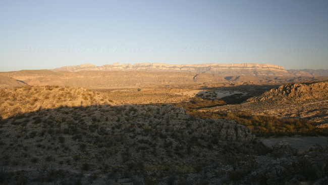
Sierra Del Carmen at sunset from the nature trail near the campground
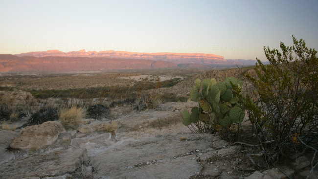
Another view of the Sierra del Carmen at sunset.
A view from the trail.
Casa Grande from a lava dike
Another view.
Casa Grande
A view from the top of the ridge
The ridge at the end of the trail.
Sierra Del Carmen at sunset from the nature trail near the campground
Another view of the Sierra del Carmen at sunset.
Saturday, January 21, 2006
This is One Big Park
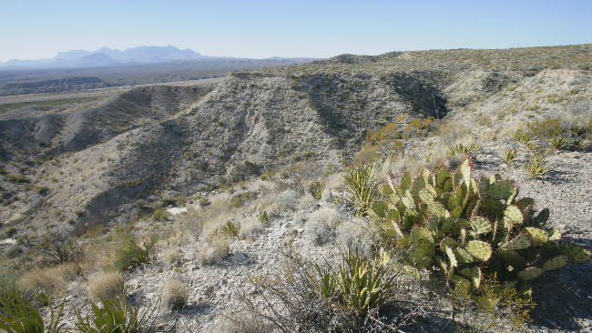
Day three of exploring the park. Our first adventure of the day was a drive down Paint Gap Road. The first section of the road was mostly gravel, the second section was stones that kept getting larger. When parts of the road looked washed out we decided it was time to turn around. We did manage to drive far enough to see the Paint Gap Hills in the distance.
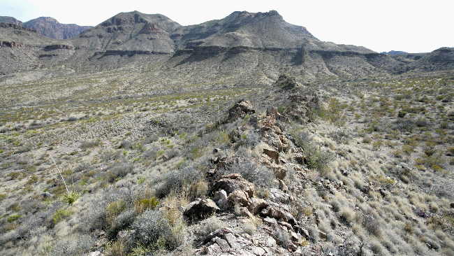
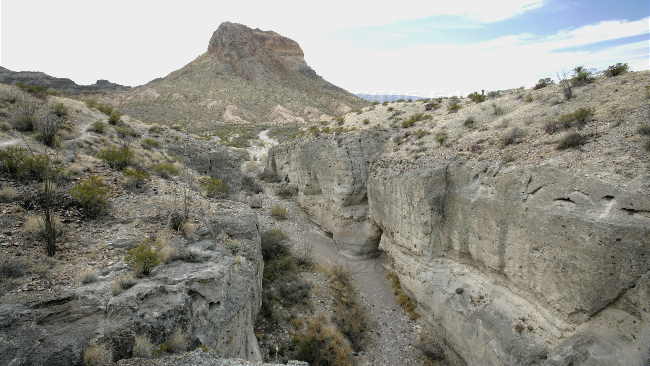
The next part of the adventure was a drive down paved Maverick Drive and paved Ross Maxwell Scenic Drive (no nail biting). The road passed through some different terrains — the Burro Messa, the Oak Creek area that once was the best grazing land in West Texas, dikes (rock outcroppings), a high scenic view point from which you can see Santa Elena Canyon 14 miles away, Tuff Canyon (a narrow canyon cut into soft gray rock called tuff, which is compressed volcanic ash), Cerro Castellan (the peak is made up of a high stack of volcanic rocks), an area of white tuff and black basaltic boulders, flood plains that were farmed in the 20's and 30's and finally Santa Elena Canyon. The Rio Grande flows through the Santa Elena Canyon with Mexico on one side and the US on the other side. You can hike about one mile into the canyon and look up at the 1,500 foot walls that tower above you.
The last part of the adventure was a the drive back on the gravel Old Maverick Drive (not bad at all). This road runs through relatively flat, barren country. The desert colors of the badlands made the drive worth while.
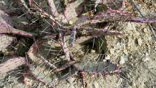
Red tinge prickly pear --- look at the size of the those spines.
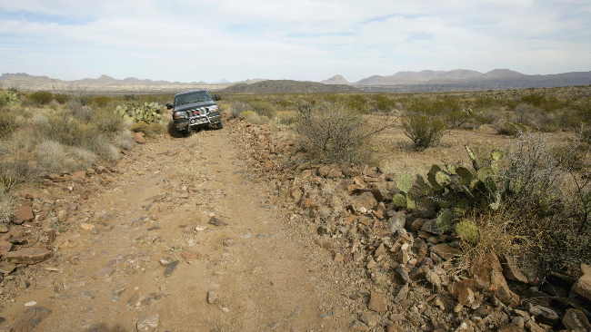
Paint Gap Road --- that's the hills in the background
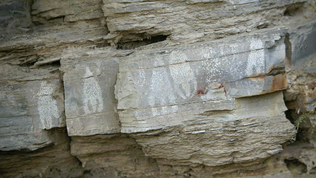
A dike was formed when molten material was squeezed into cracks beneath the earth's surface. The surrounding rock layers have since been eroded away, leaving the harder dikes standing.
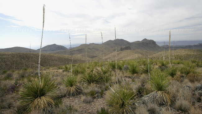
A field of sotol, large bright green plants with sharp teeth along the margins of the leaves (a member of the agave family).
Interesting layering in the rocks near Burro Mesa Pouroff
Tuff canyon
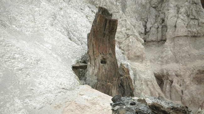
A "lava neck" that cooled and hardened in a vent from which lava probably flowed. It looks like a petrified tree.
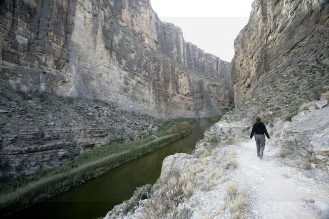
Santa Elena Canyon
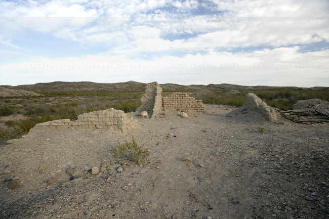
Ruins at Terlingua Abajo.
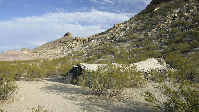
Luna's Jacal; a jacal is a primitive Mexican house-shelter typical of earliest pioneer settlements.
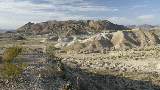
The "badlands", colour clays deposited about 70 million years ago in the Cretaceous Period.
The next part of the adventure was a drive down paved Maverick Drive and paved Ross Maxwell Scenic Drive (no nail biting). The road passed through some different terrains — the Burro Messa, the Oak Creek area that once was the best grazing land in West Texas, dikes (rock outcroppings), a high scenic view point from which you can see Santa Elena Canyon 14 miles away, Tuff Canyon (a narrow canyon cut into soft gray rock called tuff, which is compressed volcanic ash), Cerro Castellan (the peak is made up of a high stack of volcanic rocks), an area of white tuff and black basaltic boulders, flood plains that were farmed in the 20's and 30's and finally Santa Elena Canyon. The Rio Grande flows through the Santa Elena Canyon with Mexico on one side and the US on the other side. You can hike about one mile into the canyon and look up at the 1,500 foot walls that tower above you.
The last part of the adventure was a the drive back on the gravel Old Maverick Drive (not bad at all). This road runs through relatively flat, barren country. The desert colors of the badlands made the drive worth while.
Red tinge prickly pear --- look at the size of the those spines.
Paint Gap Road --- that's the hills in the background
A dike was formed when molten material was squeezed into cracks beneath the earth's surface. The surrounding rock layers have since been eroded away, leaving the harder dikes standing.
A field of sotol, large bright green plants with sharp teeth along the margins of the leaves (a member of the agave family).
Interesting layering in the rocks near Burro Mesa Pouroff
Tuff canyon
A "lava neck" that cooled and hardened in a vent from which lava probably flowed. It looks like a petrified tree.
Santa Elena Canyon
Ruins at Terlingua Abajo.
Luna's Jacal; a jacal is a primitive Mexican house-shelter typical of earliest pioneer settlements.
The "badlands", colour clays deposited about 70 million years ago in the Cretaceous Period.
Friday, January 20, 2006
Hot Springs
Another full day to explore the park. Today’s tour took us up Grapevine Hills Road to Balancing Rock, Chisos Basin and Hot Springs Road to the hot springs. Grapevine Hills Road is a partially improved dirt road turning into a rougher dirt road — actually not bad. The first mile of the hike was through the desert but the last quarter mile of the hike was more interesting as you had to scramble up some rocks to the Balancing Rock. It was pretty amazing — definitely worth the hike.
Chisos Basin was like a different world — still some desert but a lot more trees (pinyon pine, oaks and junipers). We saw a small herd of Carmen Mountains whitetail deer by the parking lot in the basin. There are several trails that start here and we opted to hike the two shortest and easiest — maybe we will be more adventurous on another visit to the park (the other trails are full day hikes).
The last stop of the day was Hot Springs Road and the hot springs. The family homesteading this part of the park from 1909 to 1916 developed a small health resort utilizing the spring’s natural hot water for baths. The hot spring continues to bubble up in the ruins of the bath house and many park visitors sit in the maybe 2 foot deep 105F degree water. Ed and I joined a group of people sitting in the spring.
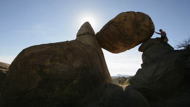
Hmmm, can I push the rock down?
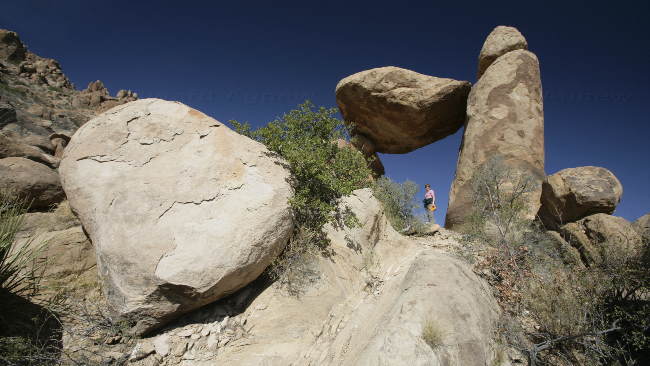
I hope the rock doesn't fall.
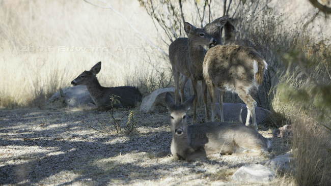
Carmen Mountains whitetail deer
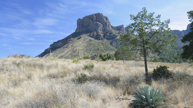
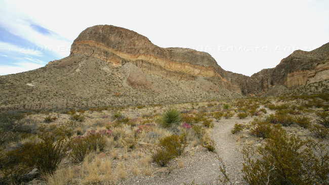
The mountain is called Casa Grande as it looks like a large fort or castle.
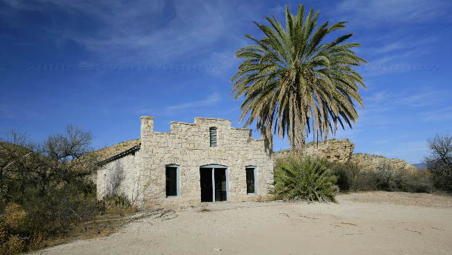
The remains of a store out by the hotsprings.
Petroglyphs near the hot springs trail.
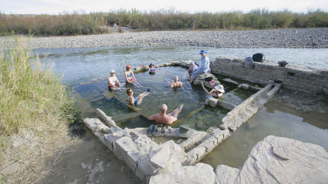
The hot springs are only separated from the Rio Grande by a stone wall. Mexico is about 15 feet away.
Chisos Basin was like a different world — still some desert but a lot more trees (pinyon pine, oaks and junipers). We saw a small herd of Carmen Mountains whitetail deer by the parking lot in the basin. There are several trails that start here and we opted to hike the two shortest and easiest — maybe we will be more adventurous on another visit to the park (the other trails are full day hikes).
The last stop of the day was Hot Springs Road and the hot springs. The family homesteading this part of the park from 1909 to 1916 developed a small health resort utilizing the spring’s natural hot water for baths. The hot spring continues to bubble up in the ruins of the bath house and many park visitors sit in the maybe 2 foot deep 105F degree water. Ed and I joined a group of people sitting in the spring.
Hmmm, can I push the rock down?
I hope the rock doesn't fall.
Carmen Mountains whitetail deer
The mountain is called Casa Grande as it looks like a large fort or castle.
The remains of a store out by the hotsprings.
Petroglyphs near the hot springs trail.
The hot springs are only separated from the Rio Grande by a stone wall. Mexico is about 15 feet away.
Thursday, January 19, 2006
Rocks
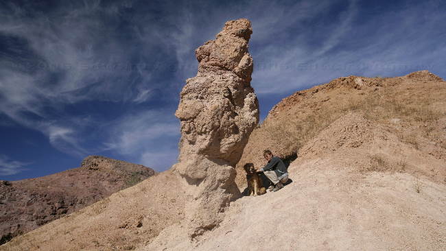
Today was our first full day to explore the park. It’s not a great place for Zaph as he’s not allowed on any of the trails (National Park thing). It’s a very large, very beautiful park and we’re planning on staying for five nights so we’ll just have to walk Zaph around the campground a lot. On our tour today was the Boquillas Canyon and Old Ore Road (a 4x4 dirt road). The trail to the Boquillas Canyon led you to the Rio Grande River with a great view of Mexico. The village of Boquillas, Mexico is just across the river and 9/11 has totally changed their lives. Before 9/11 tourists were allowed to cross the river, visit the town, perhaps have lunch and a beer or soda, buy souvenirs and return to the park without any problems. Now you can only cross at border crossings and the nearest one is 100 miles away — no more tourists for Boquillas. A few enterprising Mexicans try to sell items from across the river but can be fined and even imprisoned if they are caught.
The drive on the Old Ore Road was bumpy but interesting. It’s hard to believe that this desert area was once ranches supporting horses and cattle. Unfortunately lack of rain after overgrazing caused the grassland to turn to desert. One of the interesting places on the road is the Ernst Tinaja. You walk up a canyon to the huge tinaja (bowls) that were carved into the massive limestone creek bed by water. The cliffs above it consist of tuff (volcanic ash), yellow, gray and reddish-brown limestone and shales about 450 feet thick. Further along the road we met up with a car going the opposite direction, Ed indicated that there was some pretty rough road ahead but the driver of the car continued anyway — hope he made it as his car didn’t have a lot of clearance.
Back at the trailer, Zaph alerted us to the fact that 2 coyotes crossed the road by the trailer. Lots of wildlife in this park.
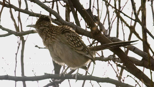
First time we say a Road Runner in a tree.
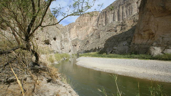
Boquillas Canyon . That's Mexico on the other side of the Rio Grande.
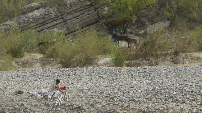
A Mexican with walking sticks he was trying to see. A couple of burros in the brush chowing down.
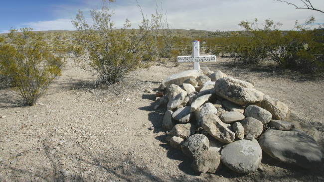
A grave along side the Old Ore Road.
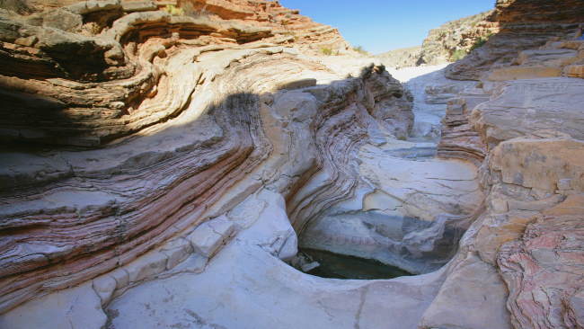
Ernst Tinaja
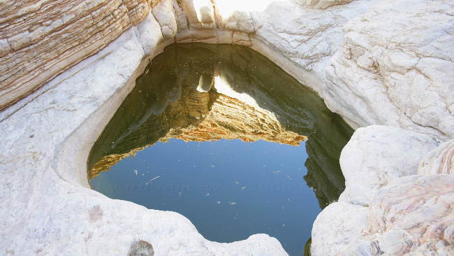
Looking down into the tinaja.
A view across the desert.
The drive on the Old Ore Road was bumpy but interesting. It’s hard to believe that this desert area was once ranches supporting horses and cattle. Unfortunately lack of rain after overgrazing caused the grassland to turn to desert. One of the interesting places on the road is the Ernst Tinaja. You walk up a canyon to the huge tinaja (bowls) that were carved into the massive limestone creek bed by water. The cliffs above it consist of tuff (volcanic ash), yellow, gray and reddish-brown limestone and shales about 450 feet thick. Further along the road we met up with a car going the opposite direction, Ed indicated that there was some pretty rough road ahead but the driver of the car continued anyway — hope he made it as his car didn’t have a lot of clearance.
Back at the trailer, Zaph alerted us to the fact that 2 coyotes crossed the road by the trailer. Lots of wildlife in this park.
First time we say a Road Runner in a tree.
Boquillas Canyon . That's Mexico on the other side of the Rio Grande.
A Mexican with walking sticks he was trying to see. A couple of burros in the brush chowing down.
A grave along side the Old Ore Road.
Ernst Tinaja
Looking down into the tinaja.
A view across the desert.
Wednesday, January 18, 2006
Billions and Billions of Stars
Ed still wasn’t a happy camper — he didn’t feel comfortable with the tire repair given where we were headed so he decided to track down a tire repair shop. They were able to fix the tire in no time at all. Big Bend National Park is very isolated — no cellular phone service, no internet, one small town is about 43 miles from the campground where we would be staying and a small town in the other direction is 89 miles. This is also why the blog wasn’t updated for more than a week. After running a couple of errands we were on the road headed to Big Bend. The drive was through a desert area (what else would you expect) and we saw lots of road runners, some quail and a couple of coyote. We arrived at the campground, found a spot and setup. When Margaret and Colin landed they had an encounter with Javelinas (pronounced hav-uh-Lee-nuh) also known as collared peccaries. These critters resemble pigs, but are not closely related to pigs at all and have been genetically distinct from them for millions of years. Later the band of Javelinas marched through our campsite heading back into the woods — these are brave critters as one walked to within 2 feet of Ed who busy taking its picture.
Ed had been told that the sunset from the nature trail was wonderful, so we headed out to the trail just before sunset — and it was very beautiful. While we were enjoying the sunset we started chatting with another couple. Turns out that they are Australians who have come to the North America for a year. They purchased a truck and a camper back and have been touring since last July. In June they will return to Australia with hopes of returning the following February for another year — and we thought we were adventurous.
Lastly, we took Zaph for a walk after supper and were totally awe struck when we looked up at the sky and saw all the stars. There’s a definite benefit to being remote.
Now that's one big Road Runner
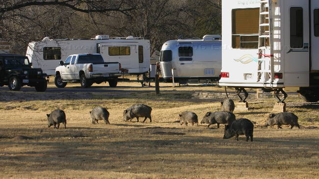
Javelinas trucking through the campground
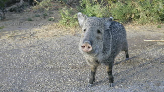
What's for dinner?
A view from the nature trail.
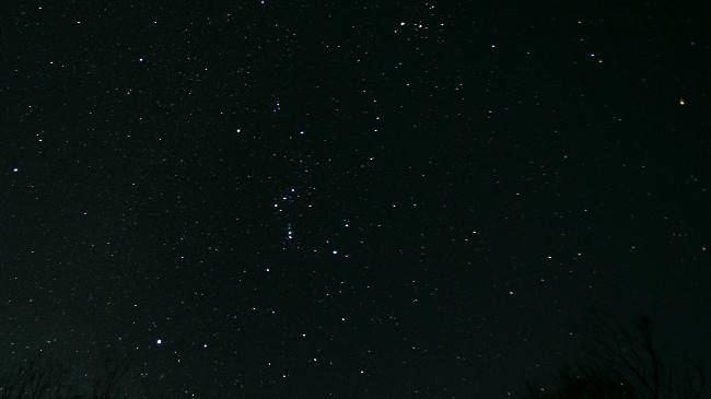
Can you make out Orion?
Ed had been told that the sunset from the nature trail was wonderful, so we headed out to the trail just before sunset — and it was very beautiful. While we were enjoying the sunset we started chatting with another couple. Turns out that they are Australians who have come to the North America for a year. They purchased a truck and a camper back and have been touring since last July. In June they will return to Australia with hopes of returning the following February for another year — and we thought we were adventurous.
Lastly, we took Zaph for a walk after supper and were totally awe struck when we looked up at the sky and saw all the stars. There’s a definite benefit to being remote.
Now that's one big Road Runner
Javelinas trucking through the campground
What's for dinner?
A view from the nature trail.
Can you make out Orion?
Tuesday, January 17, 2006
Driving, Driving, Driving Keep Them Trucks a Driving
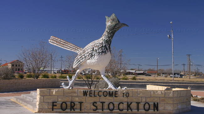
I’m not totally sure why but we decided that we would head straight to Big Bend National Park in Texas from Arizona skipping New Mexico (I guess we’ll have to see it next year). The drive was split into a long day and a shorter day. This being the case we thought a Wal-Mart parking lot would be a good place to stay. They only problem was there aren’t a lot of Wal-Marts between the New Mexico border and Big Bend as there are almost no towns. After much research we found a Wal-Mart in Fort Stockon — 8 hours of driving time at highway speeds. This translated into a 12 hour day as we stopped a couple of times and drove slower than the posted 75 mph speed limit.
When we went to the Western Horizon spiel the previous day each couple was given a cheque for $50 (the pamphlet indicated that but we didn’t expect it, we were just happy getting 3 nights free). As we don’t have US bank accounts we searched the internet for a branch of Western Horizon’s bank that was on our route. We found one in a small town in New Mexico. Margaret and I were amazed at how easy it was to cash our cheques — two pieces of ID (one of them picture ID) and a thumb print. Does this mean we are in database somewhere and can be tracked?
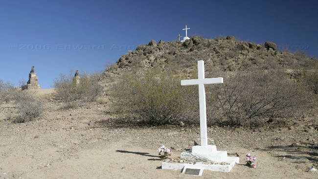
We also saw one unusual thing while we were driving — a man walking on the side of the highway carrying a large cross. Does anyone know what that’s about?
The Wal-Mart RV park was fine and I was actually surprised at the number of RV’s in the lot for the night. Ed was not a happy camper though as he noticed the right front tire on the truck was low — taking a closer look he found a nail in it. As he had some tire goop he put it in the tire and it appeared to do the trick.
When we went to the Western Horizon spiel the previous day each couple was given a cheque for $50 (the pamphlet indicated that but we didn’t expect it, we were just happy getting 3 nights free). As we don’t have US bank accounts we searched the internet for a branch of Western Horizon’s bank that was on our route. We found one in a small town in New Mexico. Margaret and I were amazed at how easy it was to cash our cheques — two pieces of ID (one of them picture ID) and a thumb print. Does this mean we are in database somewhere and can be tracked?
We also saw one unusual thing while we were driving — a man walking on the side of the highway carrying a large cross. Does anyone know what that’s about?
The Wal-Mart RV park was fine and I was actually surprised at the number of RV’s in the lot for the night. Ed was not a happy camper though as he noticed the right front tire on the truck was low — taking a closer look he found a nail in it. As he had some tire goop he put it in the tire and it appeared to do the trick.
Monday, January 16, 2006
Winter Comes to Southern Arizona
When we woke up this morning it was approximately37F (3.5C) with a forecast high of 51F. The forecast is for sub freezing temperatures tonight with a high of 56F on Tuesday. On top of the cool temperatures there is a cold wind ---- burrrr. I admit I’m a wimp — I pulled out my parka.
This morning we went to the spiel on Western Horizon — very interesting but not for us at this time. After lunch we went for a drive and then took Zaph for a hike at the San Pedro Riparian National Conservation Area. The spot we picked was the site of the old mining town of Fairbank. There’s not much left of the town, some old falling down buildings, remains of the cemetery and the ruins of the old stamping mill. Zaph didn’t care about the town but he really enjoyed the walk.
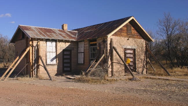
The old school house.
A shot of the graveyard.
Zaph checking out the view.
This morning we went to the spiel on Western Horizon — very interesting but not for us at this time. After lunch we went for a drive and then took Zaph for a hike at the San Pedro Riparian National Conservation Area. The spot we picked was the site of the old mining town of Fairbank. There’s not much left of the town, some old falling down buildings, remains of the cemetery and the ruins of the old stamping mill. Zaph didn’t care about the town but he really enjoyed the walk.
The old school house.
A shot of the graveyard.
Zaph checking out the view.
Sunday, January 15, 2006
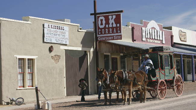
Do You Remember the Shoot Out at the OK Corral ?
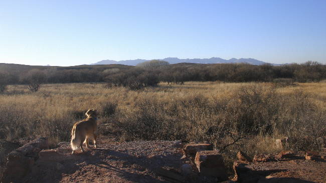
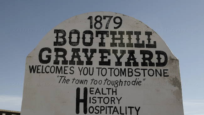
St. David is only 16 miles north of Tombstone so how could we not go there even if it is touristy. No cars are allowed on the main street of Tombstone — only people, horses, and stagecoaches. Gunslingers stand on the street corners advertising gun fights. You can see the largest rose bush if your willing to spend $3 a person, a tour of the “bird cage” ( a theater?) is $8 a person — walking down the street, a visit to boot hill or going into the shops are the only things that are free in Tombstone. Ed and I decided to go to one of the gunfights ($4 a person) and it actually was interesting. This particular “show” made an effort to tell a lot about the true history of Tombstone and how the movies have misrepresented it.
South of Tombstone is the town of Bisbee. This is a very cute town at the bottom of a small canyon. The town was established to support the copper mines in the area but now is known as an artist community.
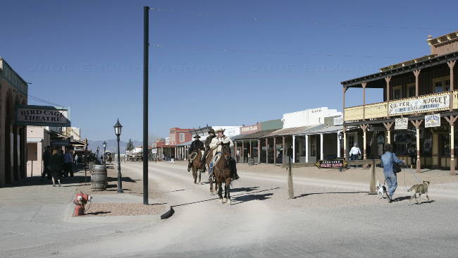
Downtown Tombstone.
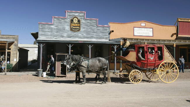
Anyone want to go for a ride?
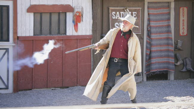
One of the gun fighters.
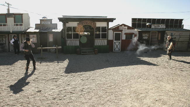
Who's going to win this fight?
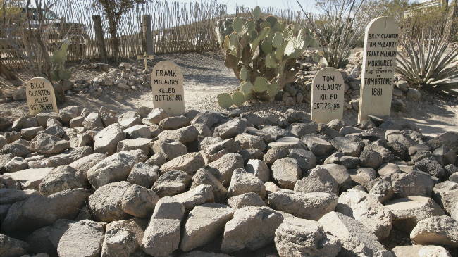
Some of the people that lay in boothill grave yard.
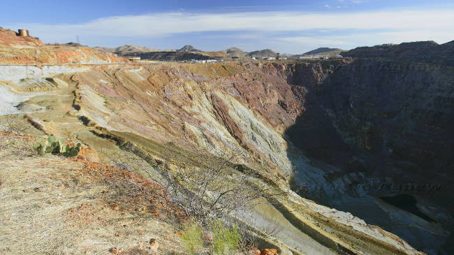
An open pit copper mine.
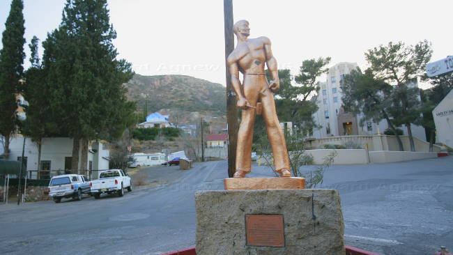
A tribute to copper miners.
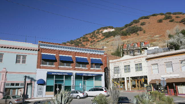
Downtown Bisbee.
South of Tombstone is the town of Bisbee. This is a very cute town at the bottom of a small canyon. The town was established to support the copper mines in the area but now is known as an artist community.
Downtown Tombstone.
Anyone want to go for a ride?
One of the gun fighters.
Who's going to win this fight?
Some of the people that lay in boothill grave yard.
An open pit copper mine.
A tribute to copper miners.
Downtown Bisbee.
Saturday, January 14, 2006
Happy Birthday Ed!!!!
Yep, it’s Ed’s birthday today and he’s going to have to drive the trailer ---- luckily we are only going about 60 miles to the small town of St. David, Az. Colin, Margaret, Ed and I walked down to the truck stop for a very good breakfast — I didn’t think Ed should have to make breakfast on his birthday.
The RV park in St. David is part of Western Horizon, a membership only campground system. Ed and Colin had been given pamphlets for 4 days 3 nights free at a Western Horizon campground at a market in Yuma. We figured what the heck, why don’t we stop and have a look, as all it is going to cost us is 90 minutes of our time — we have to listen to a spiel on Western Horizon resorts. Who knows sometime in the future, we might even think it’s a good idea.
Ed, Zaph and I drove into Benson (about 7 miles north and a slightly larger town) to check it out and look for a restaurant for Ed’s birthday dinner.. Well, there’s not a lot in Benson, but we did find a park where we took Zaph for a walk and a nice steak restaurant where we went for a very good dinner.
Friday, January 13, 2006
Trees!!!
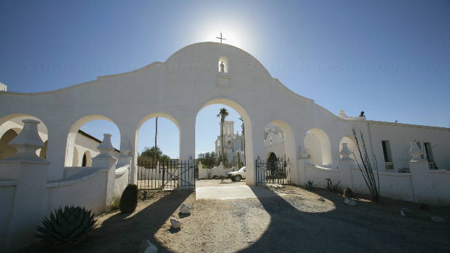
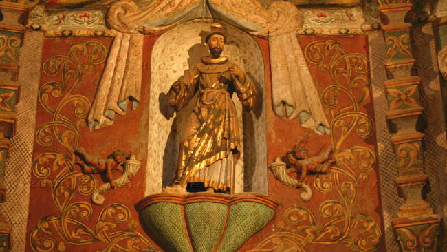
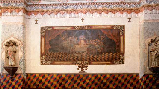
Zaph had spent the previous two days in the trailer so we decided that today he was coming with us — that meant we had to find places where they allowed dogs. The first stop was Mission San Xavier Del Bac, unfortunately one of the towers was covered in scaffolding. The Mission is known as one of the finest examples of mission architecture in the country. The interior is covered with recently restored hand painted frescos — incredible. Zaph enjoyed walking around the grounds.
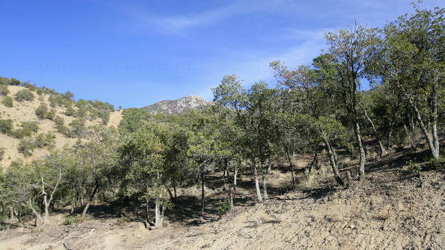
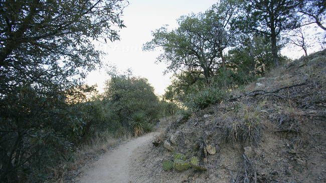
Leaving the mission we continued southeast heading into the Coronado National Forest and Madera Canyon. The mountains in this area reach over 10,000 feet – the parking lot at the end the Madera Canyon was at greater than 5,000 feet. The drive started in desert progressed through desert grassland ending in mountain woodlands. The most incredible part of the drive was when we started seeing trees — of the normal non-desert types, we hadn’t see any for awhile. While we were walking on a nature trail we noticed many dry stream beds and some prickly pear cacti amongst the trees. It’s a beautiful area and deserves more time — who knows maybe go back next year.
Leaving Madera Canyon we followed Box Canyon Road, a dirt road that eventually leads back to Tucson. At first this was a normal dirt road through the desert grassland — there were cattle grates and signs indicating that there was free ranging livestock , and eventually we saw some cattle. As the road preceded across the hills it became narrower, windier, rougher, clinging to a steep mountain wall, with no guard rails — in fact it reminded us of the road into Telegraph Creek — yeah Ed had fun driving. As we left the hills the road became a normal dirt road again and then a paved road. The remainder of the drive was on good road but through some beautiful countryside.
the mission San Xavier Del Bac
Some views from inside the mission
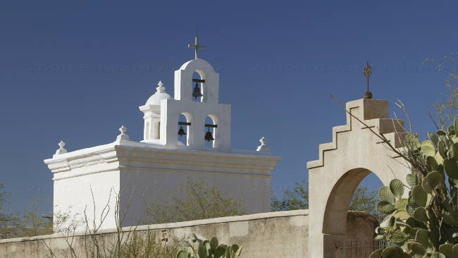
The bell tower
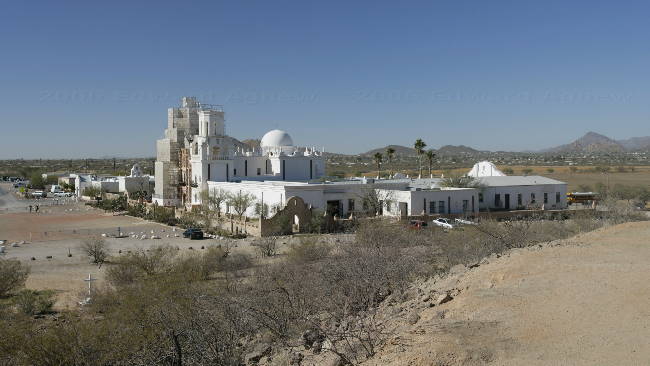
Looking down on the mission from a near by hill
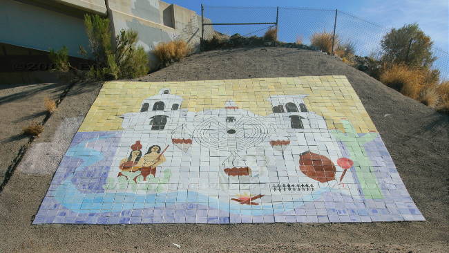
This mozaic is at the interchange at I-10 near the mission
Real trees (just like Ontario) in Arizona....
mixed types of plants, catus and trees
The fields look more like what we saw in Montana.
Leaving the mission we continued southeast heading into the Coronado National Forest and Madera Canyon. The mountains in this area reach over 10,000 feet – the parking lot at the end the Madera Canyon was at greater than 5,000 feet. The drive started in desert progressed through desert grassland ending in mountain woodlands. The most incredible part of the drive was when we started seeing trees — of the normal non-desert types, we hadn’t see any for awhile. While we were walking on a nature trail we noticed many dry stream beds and some prickly pear cacti amongst the trees. It’s a beautiful area and deserves more time — who knows maybe go back next year.
Leaving Madera Canyon we followed Box Canyon Road, a dirt road that eventually leads back to Tucson. At first this was a normal dirt road through the desert grassland — there were cattle grates and signs indicating that there was free ranging livestock , and eventually we saw some cattle. As the road preceded across the hills it became narrower, windier, rougher, clinging to a steep mountain wall, with no guard rails — in fact it reminded us of the road into Telegraph Creek — yeah Ed had fun driving. As we left the hills the road became a normal dirt road again and then a paved road. The remainder of the drive was on good road but through some beautiful countryside.
the mission San Xavier Del Bac
Some views from inside the mission
The bell tower
Looking down on the mission from a near by hill
This mozaic is at the interchange at I-10 near the mission
Real trees (just like Ontario) in Arizona....
mixed types of plants, catus and trees
The fields look more like what we saw in Montana.
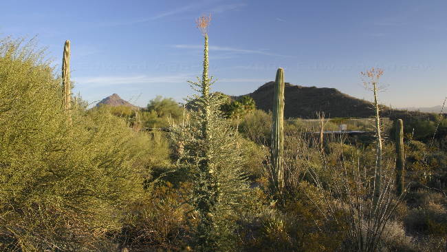
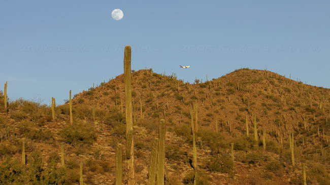
Thursday, January 12, 2006
There’s More to the Desert Than You May Think
One of the items on the list of things to do in Tucson is to visit the Center for Creative Photography on the University of Arizona campus. This of course was somewhere Ed wanted to go especially when he read that they displayed some of Ansel Adams work. Well, it was a good idea but the center was under renovation and only a few photographs were on display — happily some of them were Ansel Adams.
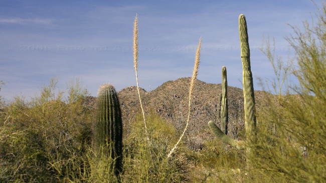
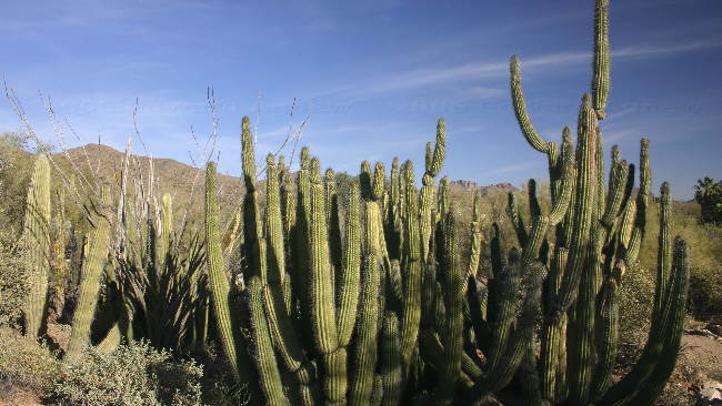
As most of the day was left we decided to head to the Arizona - Sonora Desert Museum. People in the site next to us in Yuma had told us we should not miss this museum — they were right. The drive to the museum was through some desert mountains — it was interesting to see a forest of Saguaro (tall cacti sometimes with arms) on the mountainside the same as we see pine trees in the Rockies. The museum was a little pricey but very well done. They showed all aspects of the desert: caves with bats, water and mineral, the mountain woodlands with the trees, bears, mountain lions and goats; the desert grassland with wolves, deer, prairie dogs, owls and snakes; and the desert itself with cacti, coyotes, and javelina (similar to a wild pig but it’s not a pig). There was also a walk-in aviary, a hummingbird garden with many hummingbirds, a cactus garden, an area with beaver and otter (they would have lived in the area before it dried up and became a desert) and a desert garden.
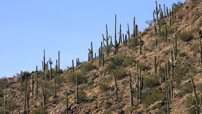
a forest of Saguaro, they start to grown their arms when they are over 50 years old
various desert plants
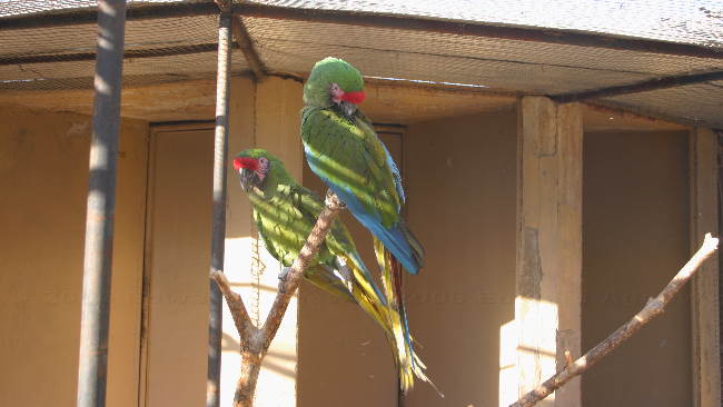
And colourful birds
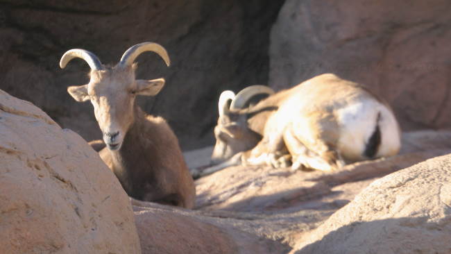
big horn sheep
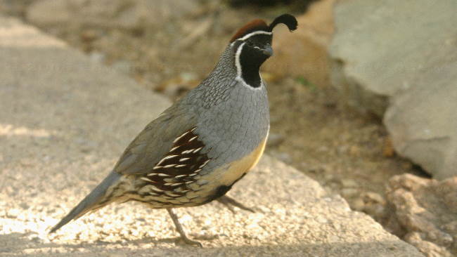
Gambel's quail
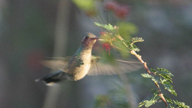
One of many humming birds
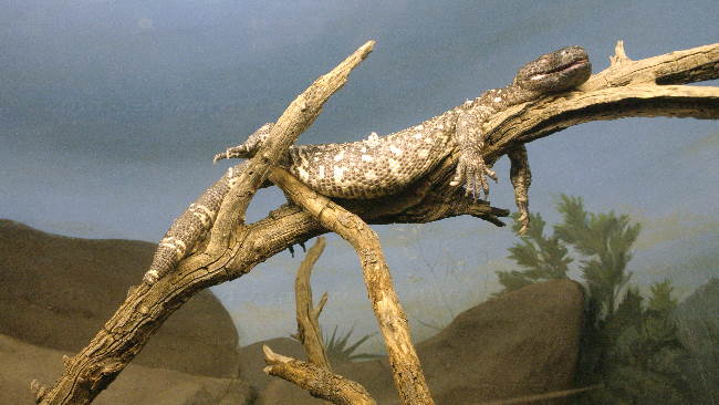
a very laid back lizard
As most of the day was left we decided to head to the Arizona - Sonora Desert Museum. People in the site next to us in Yuma had told us we should not miss this museum — they were right. The drive to the museum was through some desert mountains — it was interesting to see a forest of Saguaro (tall cacti sometimes with arms) on the mountainside the same as we see pine trees in the Rockies. The museum was a little pricey but very well done. They showed all aspects of the desert: caves with bats, water and mineral, the mountain woodlands with the trees, bears, mountain lions and goats; the desert grassland with wolves, deer, prairie dogs, owls and snakes; and the desert itself with cacti, coyotes, and javelina (similar to a wild pig but it’s not a pig). There was also a walk-in aviary, a hummingbird garden with many hummingbirds, a cactus garden, an area with beaver and otter (they would have lived in the area before it dried up and became a desert) and a desert garden.
a forest of Saguaro, they start to grown their arms when they are over 50 years old
various desert plants
And colourful birds
big horn sheep
Gambel's quail
One of many humming birds
a very laid back lizard
Wednesday, January 11, 2006
Here an Airplane, There an Airplane, Everywhere an Airplane
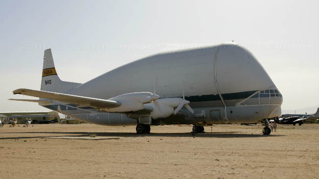
One of the must see items in Tucson is the Pima Air and Space Museum and with Ed on this trip, the museum was a definite stop for us. The museum sits on approximately 75 acres, has 5 hangers with displays and over a hundred airplanes on the tarmac. One of the tours that is offered by the museum is of the Aircraft Maintenance and Regeneration Center (AMARC) down the road at the Davis-Monthan Air Force Base. This center stores aircraft for a variety of reasons: sale, future use, parts, or destruction —and there were a lot of aircraft there! Arizona was chosen as the location for the storage site due to the weather and the fact that the desert soil is so firm that the planes can be parked on it — no tarmac required. As you can imagine Ed had a great day.
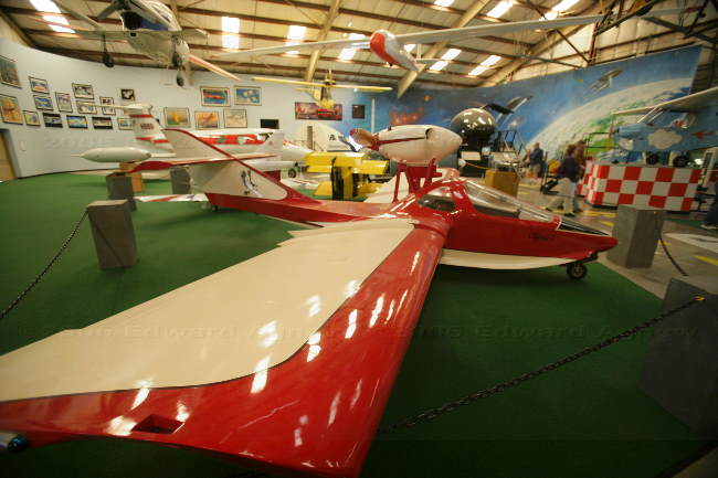
Lots of toys
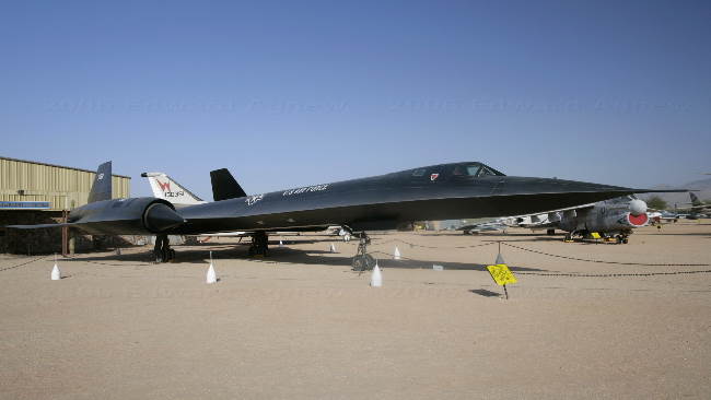
One of my favorites, the SR-71 Blackbird, made the trip from ocean to ocean across the US in just over 68 minutes
OOPS... I over inflated the airplane again!----
An Aero Spacelines 377SG Super Guppy, first flown in 1965 to carry full sized booster rocket stages, this aircraft can carry 40,000 lbs at 265 MPH provided the cargo is not over 25 feet in diameter.
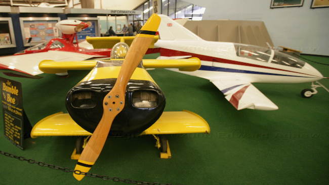
Front left, the Bumble bee, smallest aircraft in the world, that a person can fly in, 6'6" wingspan, 9'4" length, top speed 180 MPH, fuel capacity of 3 gallons. Right rear: a BD-5J microjet, the world's smallest jet, this one was featured in the James Bond movie "Octopussy" from 1983, Max speed 320 MPH, service ceiling 26,000 ft.
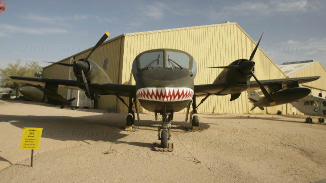
a mean looking Grumman OV-1C Mohawk reconnaissance aircraft, active army use from 1959 to present
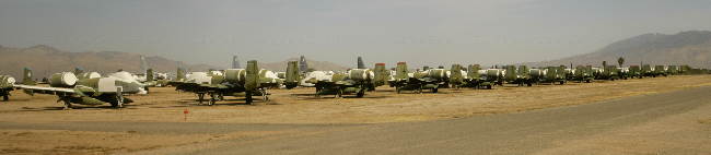
A long line of out of service A-10 tankbuster aircraft
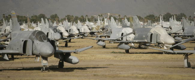
Likewise many out of service F4 phantom fighter, soon to be converted to drones (remotely controlled aircraft)
Lots of toys
One of my favorites, the SR-71 Blackbird, made the trip from ocean to ocean across the US in just over 68 minutes
OOPS... I over inflated the airplane again!----
An Aero Spacelines 377SG Super Guppy, first flown in 1965 to carry full sized booster rocket stages, this aircraft can carry 40,000 lbs at 265 MPH provided the cargo is not over 25 feet in diameter.
Front left, the Bumble bee, smallest aircraft in the world, that a person can fly in, 6'6" wingspan, 9'4" length, top speed 180 MPH, fuel capacity of 3 gallons. Right rear: a BD-5J microjet, the world's smallest jet, this one was featured in the James Bond movie "Octopussy" from 1983, Max speed 320 MPH, service ceiling 26,000 ft.
a mean looking Grumman OV-1C Mohawk reconnaissance aircraft, active army use from 1959 to present
A long line of out of service A-10 tankbuster aircraft
Likewise many out of service F4 phantom fighter, soon to be converted to drones (remotely controlled aircraft)
Tuesday, January 10, 2006
On the Road Again
The approximately 5 hour drive from Yuma to Tucson was uneventful —just lots of desert. Margaret had picked a RV park from the Woodalls book but unfortunately we didn’t meet the criteria — unless we could make them believe that Zaph weighs less than 20 pounds! The Crazy Horse RV park wasn’t far away and we met their criteria so it’s our home for the next few days.
Ed and I were busy setting up when 2 falcons came over a hedge and appeared to be diving at us — only it wasn’t us they were after but a jack rabbit. One of the birds got a hold of the rabbit and went into the hedge. After a lot of noise and commotion the jack rabbit came flying out of the hedge and headed off through the RV park as fast as he could hop. The falcon returned to his perch on the pole being held by a man in the field on the other side of the hedge. The two birds were being used to hunt.
Ed and I were busy setting up when 2 falcons came over a hedge and appeared to be diving at us — only it wasn’t us they were after but a jack rabbit. One of the birds got a hold of the rabbit and went into the hedge. After a lot of noise and commotion the jack rabbit came flying out of the hedge and headed off through the RV park as fast as he could hop. The falcon returned to his perch on the pole being held by a man in the field on the other side of the hedge. The two birds were being used to hunt.
Monday, January 09, 2006
Packing Up
January 8 to January 9
It's time to get organized to hit the road again as we are leaving Yuma tomorrow (January 10). I'm sad to be leaving as I really enjoyed the town, the desert and the park but am looking forward to be traveling again. Zaph will miss this RV park as everyone has been telling us that the "dog park" is very unique --- luckily I won't be able to understand him when whines about leaving! Sunday was spent doing errands and Monday was spent cleaning, doing laundry and organizing the trailer.
It's time to get organized to hit the road again as we are leaving Yuma tomorrow (January 10). I'm sad to be leaving as I really enjoyed the town, the desert and the park but am looking forward to be traveling again. Zaph will miss this RV park as everyone has been telling us that the "dog park" is very unique --- luckily I won't be able to understand him when whines about leaving! Sunday was spent doing errands and Monday was spent cleaning, doing laundry and organizing the trailer.
Saturday, January 07, 2006
Return to Quartzsite
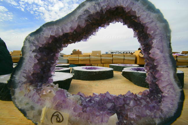
We were up early today and on the road to Quartzsite just after 8 am — Ed wasn’t sure there was such a thing as 8 am (nice to be retired!). Quartzsite is a good hour and half drive from Yuma. The town of Quartzsite blossoms in the winter when all of the RVers arrive and we were curious to see what it would be like closer to peak season (we stopped there at the end of November when people were just starting to arrive). It wasn’t as busy as I had expected but there were a lot more RVs especially out on the BLM land and the flea markets had many more vendors. There was a Rock and Gem Show on this weekend which meant there were there a few extra vendors (wholesalers) there. I’m not sure what rocks normally sell for but I think the prices were very good as resellers were loading up pickup trucks with goods. You could buy the rocks in their originally rock form, cut, cut into slabs and polished or finished into smaller sizes to be used in jewelry. They also had geods in many sizes — some of them 3 feet tall.
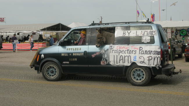
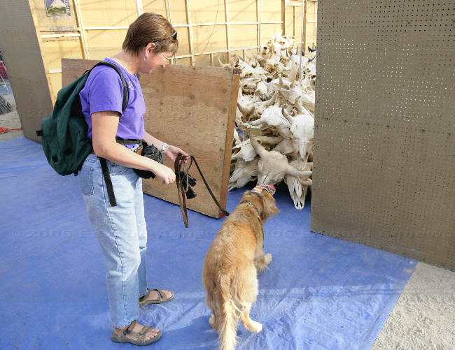
The markets sell everything you can image — kitchen items, tools, quilts, carpets, fur pelts, food, cow skulls, etc. Zaph didn’t like the cow skulls — he kept trying to sneak up on them but would back away before he got too close (I thought it was pretty creepy too). Zaph, decked out in his Arizona hat and bandana, enjoyed the outing as he received a lot of pets and even some treats. As always you see some interesting sites — one family had their dog and cat with them (the cat was in a carrier that was worn as a backpack; a couple of dogs were is specially designed dog strollers and seemed to be enjoying the ride (we saw two types of strollers); three small dogs were riding in a little red wagon looking like they were having a great time.
One of the many flea markets
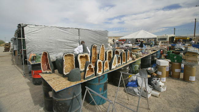
Many rocks and gems
Talk about your back seat driver
Mom... I don't want to be here!
Zaph sacked out after a hard day of shopping.
The markets sell everything you can image — kitchen items, tools, quilts, carpets, fur pelts, food, cow skulls, etc. Zaph didn’t like the cow skulls — he kept trying to sneak up on them but would back away before he got too close (I thought it was pretty creepy too). Zaph, decked out in his Arizona hat and bandana, enjoyed the outing as he received a lot of pets and even some treats. As always you see some interesting sites — one family had their dog and cat with them (the cat was in a carrier that was worn as a backpack; a couple of dogs were is specially designed dog strollers and seemed to be enjoying the ride (we saw two types of strollers); three small dogs were riding in a little red wagon looking like they were having a great time.
One of the many flea markets
Many rocks and gems
Talk about your back seat driver
Mom... I don't want to be here!
Zaph sacked out after a hard day of shopping.
Friday, January 06, 2006
Desert Mountains
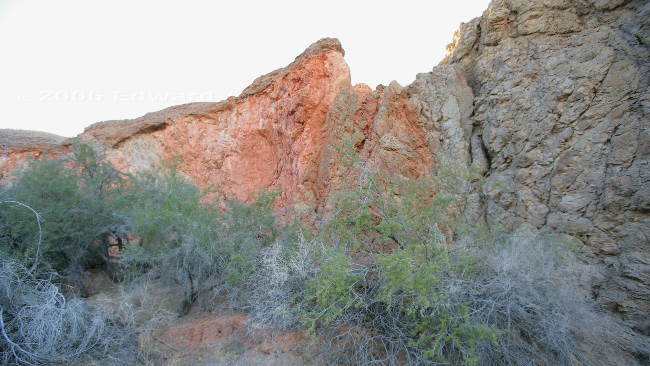
The Picacho State Recreation Area is only 29 miles from the RV resort, but it’s a very interesting 29 miles. You drive 11 miles of regular boring roads then the road changes to gravel and the terrain becomes hilly and windy. Before long you are driving through a range of low mountains created by erosion of volcanic material. In the middle of this mountainous desert area is the Colorado River and the state recreation area. Within the recreation area is the old of town of Picacho which was a booming mining town around 1900 --- all that remains are the ruins of the stamping mill buildings. The trail into the old town site yielded some beautiful views. We also hiked into Red Rock Canyon where the trail ends at a dry waterfall and the walls are a vivid red and yellow volcanic tuff capped by a sedimentary top layer. It’s hard to image the force of the water that carved the canyon. The last adventure was a 2 mile drive on a 4x4 road up into the mountain. The resulting view was beautiful and the road was very interesting — I didn’t know Ed could drive that slow! The track road was on a ridge for a bit and they were the same width! just slightly wider than the truck— didn’t want to misjudge where the wheels were.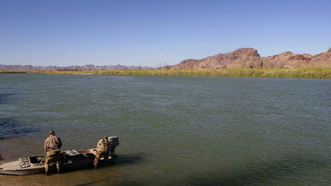
hunters loading up their boat on the Colorado River at the Picacho State Recreation Area
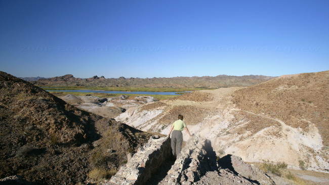
Frances takes a look over the edge of the cliff at the end of the 4x4 road up the mountain. A bridge once existed here.

Artifacts from the old stamping mill at Picacho
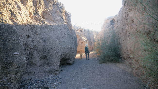
Walking along the bottom of Red Rock Canyon
Some of the vivid red and yellow volcanic tuff on the canyon walls
hunters loading up their boat on the Colorado River at the Picacho State Recreation Area
Frances takes a look over the edge of the cliff at the end of the 4x4 road up the mountain. A bridge once existed here.
Artifacts from the old stamping mill at Picacho
Walking along the bottom of Red Rock Canyon
Some of the vivid red and yellow volcanic tuff on the canyon walls
Thursday, January 05, 2006
We Went to the Centre of the World
It sounded a bit hokey but we decided to go to the Centre of the World in Felicity, California
anyway. There is a sign on the highway for Felicity leaving the population as blank — I'm pretty
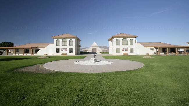
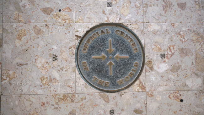
sure that means there are no permanent residents which doesn't surprise me one bit. The centre of the World is the brain child of a French children's book author. Currently, there is a pyramid plus two buildings, one housing a restaurant and exhibit, the second housing a gift shop. There were also several smaller buildings nearby which are apartments. The pyramid covers the"offical exact Centre of the World" and for $2 you can join a tour that takes you into the pyramid where the exact time you stand on the Centre of the World is recorded on a certificate, you also get to see a video. This location was certified as the Centre of the World by a French organization (I'm not sure which one). There are also a number of commemorative walls — the Korean War, the French Foreign Legion, the history of French Aviation, the history of humanity (this one has just been started), the history of a private school in New York state (the founder went there) and the founder's graduating class at Harvard. They also have on display one section from the original staircase of the Eiffel tower.
Felicity, CA, The two main building, sundail with hand pointing towards the pyramid.
this is it!!! the Centre of the world, mark it on your maps.
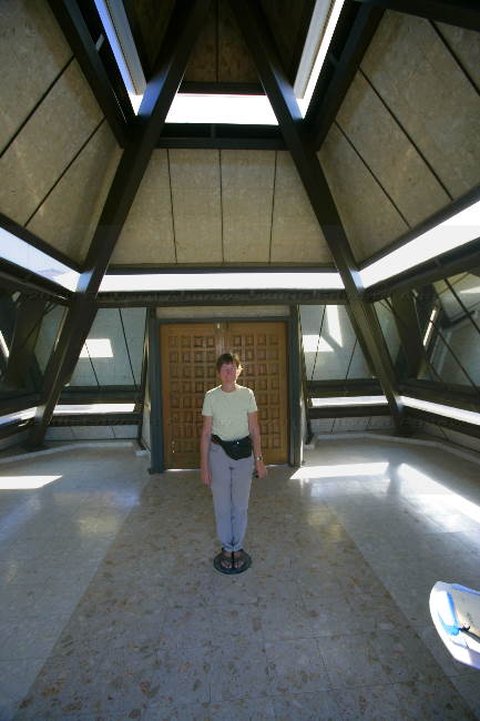
Frances standing on the "centre" OK... Scotty, beam my up now please.
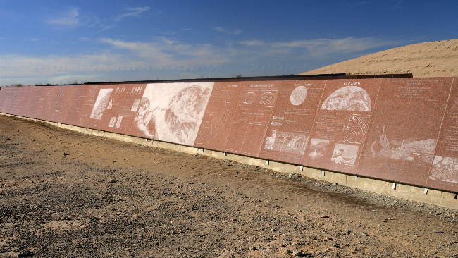
This is one of the "walls"
anyway. There is a sign on the highway for Felicity leaving the population as blank — I'm pretty
sure that means there are no permanent residents which doesn't surprise me one bit. The centre of the World is the brain child of a French children's book author. Currently, there is a pyramid plus two buildings, one housing a restaurant and exhibit, the second housing a gift shop. There were also several smaller buildings nearby which are apartments. The pyramid covers the"offical exact Centre of the World" and for $2 you can join a tour that takes you into the pyramid where the exact time you stand on the Centre of the World is recorded on a certificate, you also get to see a video. This location was certified as the Centre of the World by a French organization (I'm not sure which one). There are also a number of commemorative walls — the Korean War, the French Foreign Legion, the history of French Aviation, the history of humanity (this one has just been started), the history of a private school in New York state (the founder went there) and the founder's graduating class at Harvard. They also have on display one section from the original staircase of the Eiffel tower.
Felicity, CA, The two main building, sundail with hand pointing towards the pyramid.
this is it!!! the Centre of the world, mark it on your maps.
Frances standing on the "centre" OK... Scotty, beam my up now please.
This is one of the "walls"
Wednesday, January 04, 2006
Swimming at Last!
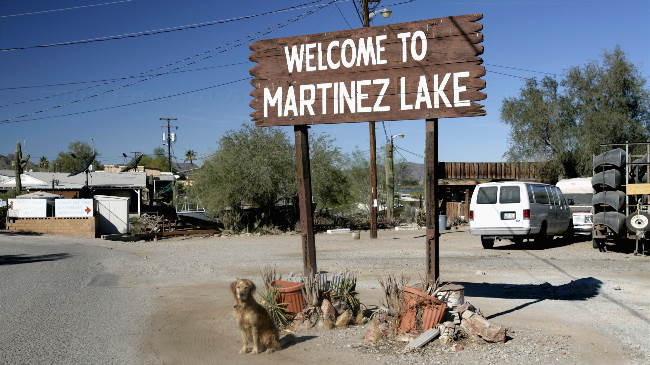
Today's drive took us to Martinez Lake and the Imperial National Wildlife Refuge. After driving
12 miles through the desert and Yuma Proving Ground (US military testing area) we arrived at
cluster of trailers. This was Martinez Lake. After parking we headed to the marina and the lake
where Zaph saw a chocolate lab swimming. I was hoping to keep the truck drive so I took Zaph
on the far side of a retaining wall. Well, he had a different idea — watching the other dog was
too much so he decided to jump onto the wall and then down 4 feet to the ground. Unfortunately, I was holding his leash but fortunately between it's length and my stretching over the wall I didn't go with him. Anyway to make a long story not too long, Zaph went swimming with the chocolate lab.
After drying Zaph off, we headed up to the wildlife refuge which consists of a visitor center,
several look out points and two marked trails. The refuge plants mullet and floods and area
inviting birds to stop during their migration. We saw a several types of ducks, moor hens and of
course many Canada Geese. Ed also saw a fox. The area terrain is also very interesting as much
of it was covered by lava flow and has now been shaped by winds and rain. We were happy to be driving a 4 wheel drive vehicle as the road tended to be hilly, windy and sandy. During the course of the day we could hear "booms"in the distance — the military must have been busy.
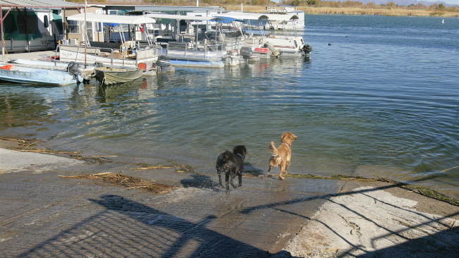
Swimming with a new friend is great!
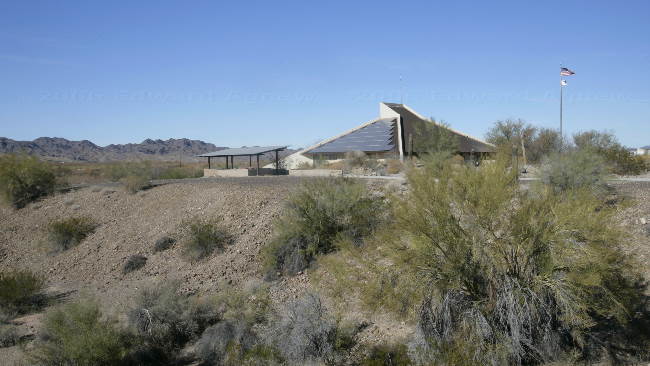
The visitor's centre for the imperial NWR
Interesting rock formation, a volcanic vent tube filled with rock, which cooled and formed this oddly shaped piece of rock which being harder than the surrounding rocks remains as the softer material wears away
a Sign post at Yuma proving grounds
some of the rugged terraine near the river
12 miles through the desert and Yuma Proving Ground (US military testing area) we arrived at
cluster of trailers. This was Martinez Lake. After parking we headed to the marina and the lake
where Zaph saw a chocolate lab swimming. I was hoping to keep the truck drive so I took Zaph
on the far side of a retaining wall. Well, he had a different idea — watching the other dog was
too much so he decided to jump onto the wall and then down 4 feet to the ground. Unfortunately, I was holding his leash but fortunately between it's length and my stretching over the wall I didn't go with him. Anyway to make a long story not too long, Zaph went swimming with the chocolate lab.
After drying Zaph off, we headed up to the wildlife refuge which consists of a visitor center,
several look out points and two marked trails. The refuge plants mullet and floods and area
inviting birds to stop during their migration. We saw a several types of ducks, moor hens and of
course many Canada Geese. Ed also saw a fox. The area terrain is also very interesting as much
of it was covered by lava flow and has now been shaped by winds and rain. We were happy to be driving a 4 wheel drive vehicle as the road tended to be hilly, windy and sandy. During the course of the day we could hear "booms"in the distance — the military must have been busy.
Swimming with a new friend is great!
The visitor's centre for the imperial NWR
Interesting rock formation, a volcanic vent tube filled with rock, which cooled and formed this oddly shaped piece of rock which being harder than the surrounding rocks remains as the softer material wears away
a Sign post at Yuma proving grounds
some of the rugged terraine near the river
Tuesday, January 03, 2006
Yuma Territorial Prison State Park
One of the attractions in Yuma is the Yuma Territorial Prison State Park. This prison operated
from 1876 to 1909 and housed both men and women. The original plan was to build the prison in Phoenix but 2 members of the legislature were from Yuma and they amended the bill changing the prison's location to Yuma. The prison was well situated as it was built high on a hill at the junction of the Colorado and Gila Rivers. After it closed the prison was used as a high school for Yuma students (the sports team still bear the name "criminals" or "crims", it was also used to house transients during the depression (if you couldn't prove you had a job waiting for you California you weren't allowed across the state line), also the town folks removed many of the prison walls for building materials after the city was flooded and needed to be rebuilt, and finally it was turned into a museum and state park.
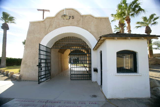
The original entry gate, a lot of the outside wall was taken away for building material after the great flood

One of the cell blocks
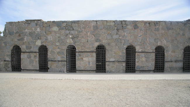
and another of the cell blocks. Over the past years, many movies, mostly westerns, have been made here using this as a background.
from 1876 to 1909 and housed both men and women. The original plan was to build the prison in Phoenix but 2 members of the legislature were from Yuma and they amended the bill changing the prison's location to Yuma. The prison was well situated as it was built high on a hill at the junction of the Colorado and Gila Rivers. After it closed the prison was used as a high school for Yuma students (the sports team still bear the name "criminals" or "crims", it was also used to house transients during the depression (if you couldn't prove you had a job waiting for you California you weren't allowed across the state line), also the town folks removed many of the prison walls for building materials after the city was flooded and needed to be rebuilt, and finally it was turned into a museum and state park.
The original entry gate, a lot of the outside wall was taken away for building material after the great flood
One of the cell blocks
and another of the cell blocks. Over the past years, many movies, mostly westerns, have been made here using this as a background.
Monday, January 02, 2006
Only one Week Left In Yuma
Checking the calendar today, we realize we have one week left in Yuma so we had better get to the site seeing we want to do.
We decided to see a few of the local sites today. Driving out of town on 95 we came to Harry McPhaul "Swinging Bridge to Nowhere". This bridge currently spans sifting sands of the desert as the great Gila River that it once bridged has been merged into the Colorado River. The bridge was built in 1929 and considered an engineering feat.
Next stop was Betty's Kitchen Wildlife and Interpretive Area. In 1983 (I think) this residential
area was flooded (there had been a restaurant called Betty's Kitchen) and the devastation was so bad that the area was turned into a park instead of trying to rebuild. There were lots of birds in this area. Leaving this area we followed the road up to Mittry Lake and then followed the canal up to the Imperial Dam. There is a lot of BLM land in this area where people park there trailers. In one spot we saw 2 burros.
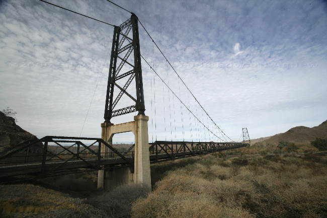
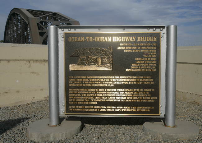
Last stop of the day was the Ocean to Ocean Bridge at the north end of Yuma. The bridge was
built in 1915 and was the only vehicular traffic bridge across the Colorado for 1,200 miles. The
bridge completed the link from the Atlantic to the Pacific through the southern states.
The Harry McPhaul bridge, an engineering marvel now only spans the drifting sands
This sign details the history of the Ocean to Ocean highway bridge
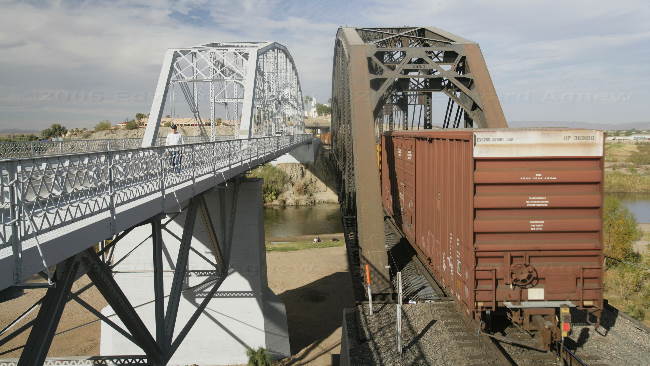
The Ocean to Ocean bridge (on the left) was the final bridge required to complete a highway from the US coast to coast, the railway bridge on the right came later
We decided to see a few of the local sites today. Driving out of town on 95 we came to Harry McPhaul "Swinging Bridge to Nowhere". This bridge currently spans sifting sands of the desert as the great Gila River that it once bridged has been merged into the Colorado River. The bridge was built in 1929 and considered an engineering feat.
Next stop was Betty's Kitchen Wildlife and Interpretive Area. In 1983 (I think) this residential
area was flooded (there had been a restaurant called Betty's Kitchen) and the devastation was so bad that the area was turned into a park instead of trying to rebuild. There were lots of birds in this area. Leaving this area we followed the road up to Mittry Lake and then followed the canal up to the Imperial Dam. There is a lot of BLM land in this area where people park there trailers. In one spot we saw 2 burros.
Last stop of the day was the Ocean to Ocean Bridge at the north end of Yuma. The bridge was
built in 1915 and was the only vehicular traffic bridge across the Colorado for 1,200 miles. The
bridge completed the link from the Atlantic to the Pacific through the southern states.
The Harry McPhaul bridge, an engineering marvel now only spans the drifting sands
This sign details the history of the Ocean to Ocean highway bridge
The Ocean to Ocean bridge (on the left) was the final bridge required to complete a highway from the US coast to coast, the railway bridge on the right came later
Sunday, January 01, 2006
Happy New Year!!!
December 26 2005 to January 1 2006
Ed and I spent some time on the tennis court this week ... we even played with another couple and didn't embarrass ourselves. Zaph had fun playing with his buddies at the park. The weather was wonderful.... even I was in shorts and the sunsets were glorious. Not a bad way to spend the last week of December.
We decided to celebrate New Years Eve at a dinner / dance at the Cocopah Casino. Margaret wore her $5 black velvet and silver jacket and I wore my $1 dress — we looked mighty fine if I say so myself. The food was pretty good — bacon wrapped scallops, prime rib and Alaskan King Crab. Desert could have been interesting — they had a chocolate fountain that didn't fountain (I guess the chocolate didn't get warm enough). The band was a Motown Review who were a lot of fun if not always on key. Margaret was happy when the hats and noise makers were handed out .... Colin was happy when the champagne was poured. We had a very nice evening but I did miss midnight in the hot tub and dancing with Jack in the kitchen
We didn't make any New Year's Resolution but are looking forward to another interesting year.
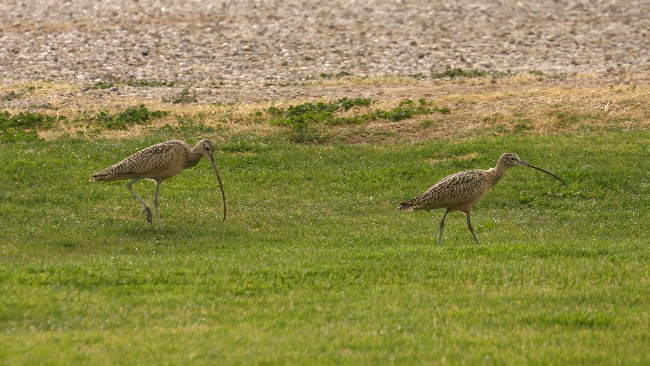
A couple of long billed curlews try to take over the dog play area
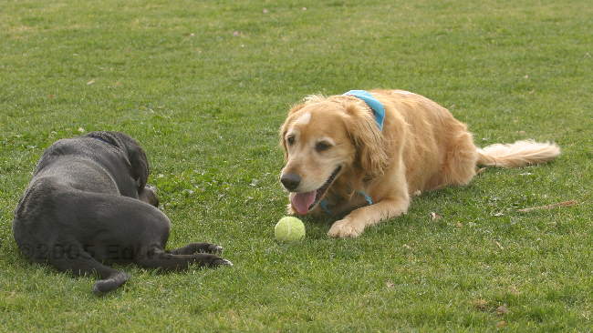
Zaphod and friend hard at play
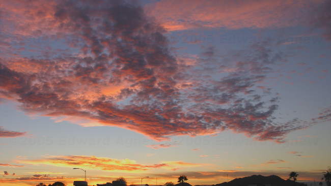
The sun sets on 2005
Party animal!!!
Ed and I spent some time on the tennis court this week ... we even played with another couple and didn't embarrass ourselves. Zaph had fun playing with his buddies at the park. The weather was wonderful.... even I was in shorts and the sunsets were glorious. Not a bad way to spend the last week of December.
We decided to celebrate New Years Eve at a dinner / dance at the Cocopah Casino. Margaret wore her $5 black velvet and silver jacket and I wore my $1 dress — we looked mighty fine if I say so myself. The food was pretty good — bacon wrapped scallops, prime rib and Alaskan King Crab. Desert could have been interesting — they had a chocolate fountain that didn't fountain (I guess the chocolate didn't get warm enough). The band was a Motown Review who were a lot of fun if not always on key. Margaret was happy when the hats and noise makers were handed out .... Colin was happy when the champagne was poured. We had a very nice evening but I did miss midnight in the hot tub and dancing with Jack in the kitchen
We didn't make any New Year's Resolution but are looking forward to another interesting year.
A couple of long billed curlews try to take over the dog play area
Zaphod and friend hard at play
The sun sets on 2005
Party animal!!!
![]()
